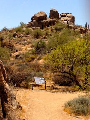
It’s the season when we all want to be outdoors. The desert, so cruel for so long, welcomes us again with open arms. If the blast-furnace heat of summer kept you off the trails for months, you’ll want to ease into things. To work yourself back into hiking shape, start with some easy trails.
Just don’t let the rating undersell their attractions.
Even trails regarded as easy reward alert hikers in countless ways. Each of these five trails delivers the full desert experience. Watch for wildlife and enjoy plenty of mild winter sunshine. Savor the big scenic views and admire the saguaros as tall as office buildings. That’s all worth getting out and walking around for a while.
GO EXPLORE:Best hikes in Phoenix; trails for every ability
Spur Cross Conservation Area
Treat yourself to a surprising bit of lushness at this park spread across upland Sonoran Desert and carved by a spring-fed stream.
Start out bearing left on the Spur Cross Trail, a segment of the mighty Maricopa Trail. It soon crosses the creek, which flows at trickle level most times. Turn right onto the Metate Trail as it weaves through a lovely mesquite bosque. Giant saguaros tower over the trail that skirts past a solar oasis pond, a popular watering hole for all sorts of critters. A little farther on you’ll find an ancient grinding stone, known as a metate.
SONORAN DESERT:Hiking at Spur Cross Ranch Conservation Area
A short (0.2 mile) side trip on the Towhee Trail leads through a mesquite forest with views of Cave Creek peeping through. Soon, Metate Trail reconnects with Spur Cross and another right turn will bring you back to the trailhead for a 2.1-mile loop.
You can extend your hiking day if you’d like. A couple of short trails branch off from this leg of Spur Cross. Mariposa Hill is a short (0.2 mile) out-and-back trail that tops a small knoll for panoramic vistas. Fairy Duster Loop (0.6 mile) circles a terrace above the creek bed shaggy with plant life. Since both these trails are named for spring flowering plants, it’s no surprise that this is a good area for bloom chasers.
Where: 37622 N. Cave Creek Road, Cave Creek. At the intersection of Cave Creek Road and Spur Cross Road, turn north on Spur Cross and go 4.5 miles to the parking area. The last 1.5 miles is unpaved but suitable for all vehicles.
Admission: $3 per person, free for age 14 and younger.
Difficulty: Easy.
Length: 2.1-mile loop; 3.1 miles if Mariposa Hill and Fairy Duster trails are added.
Details: , ext. 8; www.maricopacountyparks.net.
McDowell Sonoran Preserve
Everyone should take a walk on the Jane Rau Trail as a tribute to one of the people who spearheaded the effort to establish the McDowell Sonoran Preserve.

Jane Rau is a longtime local community activist and educator. The trail that bears her name circles through a picturesque wash in the preserve, punctuated by tall saguaros and clumps of boulders. Brown’s Mountain, a slanted hump rising from the desert floor, and the smooth precision of neighboring Cone Mountain add vertical notes to the skyline.
FAMILY HIKING:Phoenix barrier-free and stroller-friendly trails open the outdoors to all
Yet the trail is less about big vistas and more about small details. It provides a chance to move slowly and savor the little flourishes of the landscape — the way the sun splinters on the spines of teddy bear cholla, the soft landing of a butterfly on a yucca stalk and the bobbing gait of Gambel’s quail scurrying for cover.
The barrier-free trail meets accessibility standards.
Where: Brown’s Ranch Trailhead, 30301 N. Alma School Road, Scottsdale.
Admission: Free.
Difficulty: Easy.
Length: 0.4-mile loop.
Details: , www.mcdowellsonoran.org.
Lake Pleasant Regional Park
On the shores of Lake Pleasant, the 2-mile long Wild Burro Trail rambles across low hills and skirts the edge of intimate coves. It’s the water that captures your gaze, the sparkling blue dotted with ducks and kayaks and sailboats, surrounded by desert.
CHECK OUT:Lake Pleasant is a desert oasis near Phoenix. Here’s everything you can do there
But be alert for animal sightings because, as the name implies, this is one of the best chances to see wild burros in the park. Please remember they are wild, and keep a safe distance.
The last leg of the trail climbs gently into the hills before ending near the southern terminus of Pipeline Canyon Trail.
Where: 41835 N. Castle Hot Springs Road, Morristown. After entering the park, turn right on South Park Road, then left on Desert Tortoise Road. Trailhead is on Desert Tortoise Road.
Admission: $7 per vehicle.
Difficulty: Easy.
Length: 4 miles round trip.
Details: , ext. 2; www.maricopacountyparks.net.
McDowell Mountain Regional Park
This big park north of Fountain Hills offers more than 50 miles of trails. A gentle hillside loop is one of the best. The Scenic Trail would be especially beautiful following a wet winter because the slopes are covered with brittlebush.
Branching off from the rangy Pemberton Trail, Scenic makes a relatively easy loop climbing to the crest of the rolling Lousley Hills. Clusters of saguaros dot the shoulders of the hills, including a rare crested saguaro — crested on an arm instead of the top —near a midway bench.

From the high vantage point, you’ll enjoy some of the best views in the park. The McDowell Mountains rise in the west and to the east is the distinctive profile of Four Peaks, flanked by green fields of the Fort McDowell Reservation. To the south is the finger thrust of Weavers Needle poking through the furious clutter of the Superstition Mountains. Rejoining the Pemberton Trail guides you back to your starting point.
GET OUT:McDowell Mountain park is pretty busy. This trail lets you get away from the crowd
Where: 16300 McDowell Mountain Park Drive, north of Fountain Hills. After entering the park, turn right on Shallmo Drive, which leads to the Pemberton Trailhead.
Admission: $7 per vehicle.
Difficulty: Easy.
Length: 4.3-mile loop.
Details: Ext. 3, www.maricopacountyparks.net.
South Mountain Park/Preserve
The gravel path of the Kiwanis Trail gains almost 500 feet in elevation, so perhaps it should get a moderate rating. Yet it’s just 1 mile long, a short outing with dramatic city views for when you’re ready to enhance your workout a bit.
Kiwanis Trail snakes its way up through a rock-studded canyon. It stays fairly level for the first half before tilting upward. Along the way you’ll pass two small check dams built by the Civilian Conservation Corps in the 1930s. You’ll also want to watch for petroglyphs etched into boulders by ancient Hohokam people.
LIKE TO HIKE?:Hike of the week: Kiwanis Trail, South Mountain
The slightly steep stretches at the end of the trail reward your effort with expansive views of downtown Phoenix. The trail ends at Telegraph Pass Road.
If you want more of a workout, cross the road to the National Trail, where a short, steep climb leads to the Telegraph Pass lookout perched atop a ridge. It resembles a Flintstone-era gazebo but was actually built by the CCC. Catch your breath while you soak up the wide-ranging vistas. Now what trails are you ready to tackle?
Where: Trailhead is at the park’s 10919 S. Central Ave., Phoenix, entrance.
Admission: Free.
Difficulty: Easy to moderate.
Length: 2 miles round trip; 2.6 miles to Telegraph Pass lookout.
Details: , www.phoenix.gov/parks/trails/locations/south-mountain.
Find the reporter at rogernaylor.com. Or follow him on or Twitter @.
Support local journalism. Subscribe to azcentral.com today.

